


01
Water, in climatic terms
Water is the fundamental element for life on the planet, not only from a biological point of view, but also historically: ever since humans became sedentary, the first settlements were created along watercourses or on the coasts. This proximity, which has been maintained to this day, is the first factor that affects the impact of floods, the most common natural disaster globally.
Over the centuries, anthropic modifications of the territory, i.e. caused by human action, have affected the coastline and the courses of rivers, lakes, streams and other water bodies in many ways, altering their natural dynamics and resulting in the adverse effects of floods.
"Floods are natural phenomena that cannot be avoided. However, some human activities (such as increasing human settlements and economic assets in floodplains and the reduction of the natural water retention capacity of the soil) and climate change are contributing to the increased likelihood and negative impact of their occurrence. DIRECTIVE 2007/60/EC of the European Parliament and of the Council of 23 October 2007 on the assessment and management of flood risks".
Examples include the deterioration, destruction or occupation of river spaces that act as natural channels in the event of overflows, such as flood plains, meanders, wetlands and riparian forests. Also, the construction of dams and irrigation systems that alter flows, the alteration of beds by aggregate extraction, which causes them to sink, damaging the banks, the barrier effect of transport infrastructure, inadequate drainage works, etc.
Climate change also contributes to increasing the probability and severity of floods by affecting the water cycle. On the one hand, global warming causes sea levels to rise by melting the polar ice caps, which increases the mass of water. On the other hand, higher temperatures lead to more evaporation, so more water vapour accumulates in the atmosphere, generating more abundant, sudden and unpredictable precipitation. At the same time, droughts are more frequent, and their effects worsen the damage caused by floods: the loss of vegetation cover encourages erosion and dehydrated and unprotected land has no capacity to absorb large volumes of water concentrated in a short time.
The European Union has included this in the 2007/60/EC Directive on flood risk management, which Spain transposed into its legislation through Royal Decree 903 in 2010. This is the context for Ineco's work related to the climate management of water: flooding studies, in which it has more than a decade of experience, and more recently, studies on the resilience of infrastructure to the potential impacts associated with climate change.
02
Clouds on the horizon
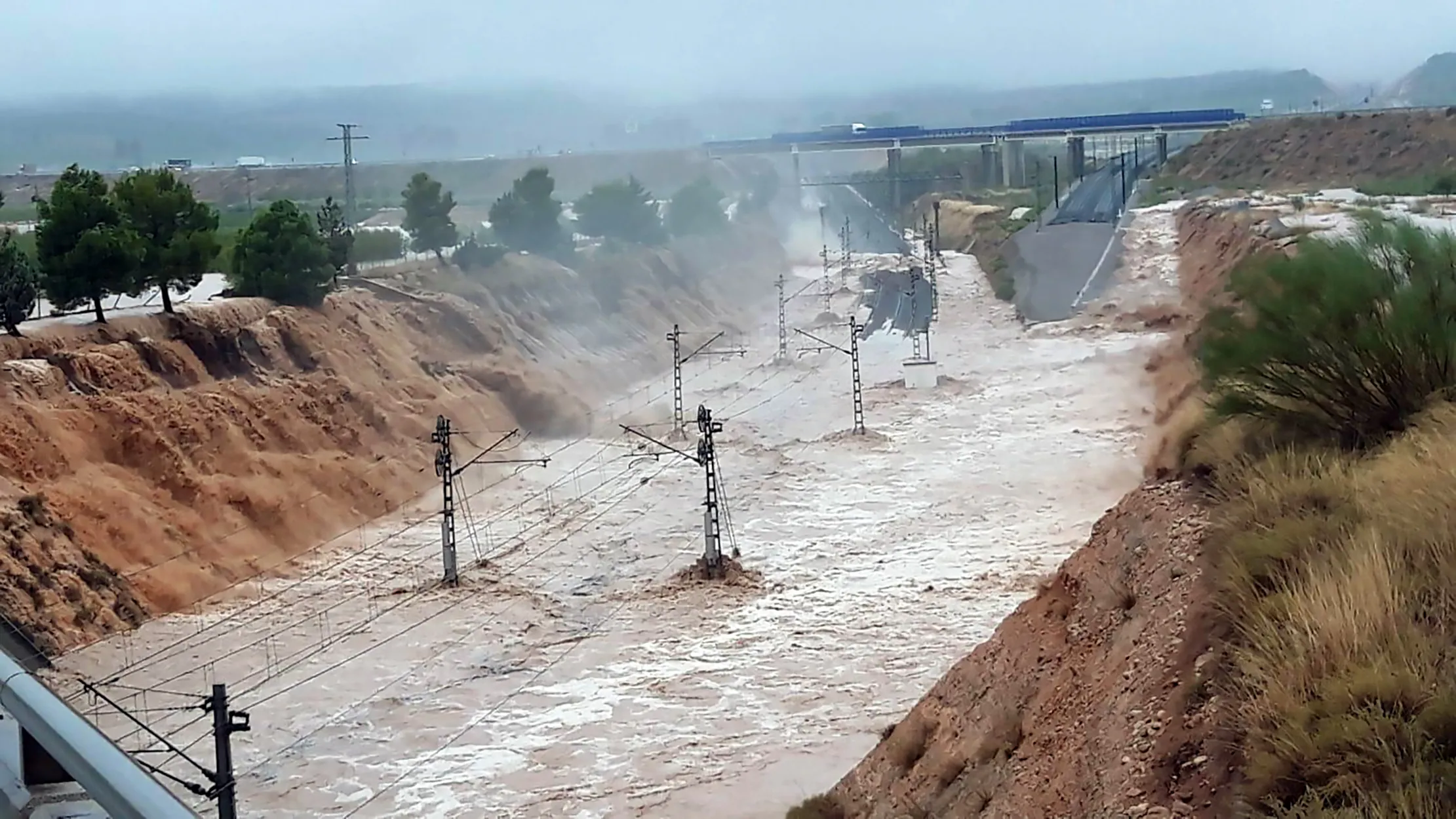
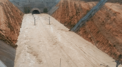
Due to its geographical location and socio-demographic characteristics, Spain is particularly vulnerable to the effects of climate change, especially in areas such as the densely urbanised and populated Mediterranean coastline and the south of the country. Research agrees that the trend is towards longer dry spells and fewer days of precipitation, but with greater intensity.
"Severe floods are becoming more frequent in Europe. More than twice as many medium to high magnitude flash floods have been recorded in recent years than in the late 1980s. Climate change is an aggravating factor, causing changes in rainfall and weather patterns, rising sea levels and, consequently, more frequent and severe flooding. Special Report of the European Court of Auditors on the Floods Directive, 2018".
The population at risk has increased from 2.5 to almost 2.7 million people, according to the recent update, or "second cycle" (2022-2027), of the Flood Risk Management Plans, (PGRIs, in Spanish), undertaken by the Ministry for Ecological Transition and the Demographic Challenge (MITECO), in accordance with the European Directive.
In addition, twice as many infrastructure located in potentially flood-prone areas have been counted, including 47 hospitals, 977 educational establishments, 347 nursing homes and 9 airports.
In addition, twice as many infrastructure located in potentially flood-prone areas have been counted, including 47 hospitals, 977 educational establishments, 347 nursing homes and 9 airports.
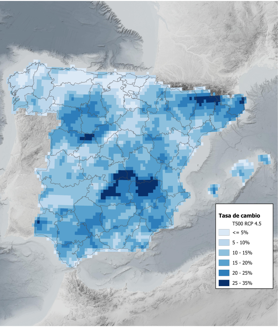
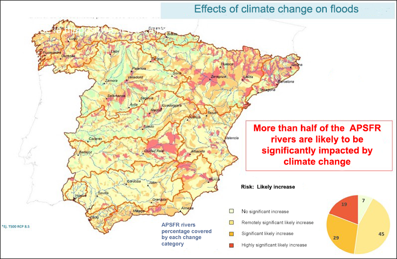
In this second cycle of Flood Risk Management Plans, the influence of climate change has also been analysed, and studies based on the report "Impact of climate change on maximum rainfall in Spain" by CEDEX (2021) make this clear: more than half of these areas, called APSFR (Areas with Significant Potential Flood Risk), will be "significantly" impacted.
The review emphasises that " knowledge-enhancing studies are one of the key elements in the implementation of the other measures of the Plans".
These measures mainly include the creation of new, more effective and coordinated networks and systems for weather forecasting, early warning and civil protection, enhancing the use of technological tools (artificial intelligence, remote sensing systems such as the European Earth observation satellite programme Copernicus), and flood protection works and actions in vulnerable areas, with an emphasis on so-called "nature-based solutions" and reinforced flood protection works and actions in vulnerable areas, with an emphasis on so-called "nature-based solutions" and strengthening climate adaptation and resilience in infrastructure.
03
Under the umbrella of knowledge
The objective of a flood study is to define the areas that would be affected in case of flooding in different present and future scenarios. Such studies are used to design flood resilient infrastructure , prevent the effects of extraordinary climatic events, minimise loss of life and economic damage, reduce maintenance costs, improve planning and risk management, and provide sustainable solutions for infrastructure adaptation to climate change.
To statistically express the probability of flooding, the concept of "return period" is used, which indicates how many years it is possible for a certain event to occur. In other words, a rainfall associated with a return period of 500 years is one that can occur once every 500 years, so it will be an extraordinary rainfall whose value will be very high.
To statistically express the probability of flooding, the concept of "return period" is used, which indicates how many years it is possible for a certain event to occur. In other words, a rainfall associated with a return period of 500 years is one that can occur once every 500 years, so it will be an extraordinary rainfall whose value will be very high.
In these studies, return periods of 100 (medium probability) and 500 years (probability low or exceptional) are usually considered. The starting point for flood studies is a DTM, a Digital Terrain Model, which is obtained from topographic data of the study area, provided by different sources: orthophotos, national cartography and other official sources. The data may not be sufficiently current or detailed, so they can also be obtained in the field by drone flights, classical topography, etc.
First, the hydrological study is carried out, which includes the pluviometric analysis, i.e. analysis of rainfall: estimating how much it rains and where ( an urban area is less permeable than a natural terrain) for how long and on what surface. A geostatistical analysis is carried out, the terrain is characterised in terms of its infiltration (water absorption capacity), and the relevant adjustments are made, by means of digitalisation based on a field visit or the most current aerial orthophotography (PNOA, National Aerial Orthophotography Plan). Finally, the design rainfall and flow rates are obtained.
In the hydraulic study, passage works, such as drains, are incorporated into the model. Source: Ineco
Once the flows and rainfall have been obtained, the hydraulic study is carried out to determine how the water moves through the territory. Channelling, ditches, drainage works, structures and any other relevant elements are incorporated into the model, as well as data on the roughness of the terrain, and the calculation meshing (division of the study area into geometric areas for precise hydraulic calculations) is carried out.Once obtained, the hydrological and hydraulic models are calibrated, comparing the statistical projections with real historical data of past floods that are incorporated into the model: photos and videos, water heights reached, satellite images, record of historical incidents...
The results of the study include an analysis of the flood hazard, with maps of the maximum depths and speed that would be reached. Once the damage has been quantified, a cost-benefit analysis is carried out and proposes solutions: improvement of drainage capacity, sub-surface water infiltration, replacement of elements susceptible to damage (e.g. a ballasted track with a slab track, or elevation of access to buildings), and protection elements such as ditches, channelling, sheet piling, walls or mounds, ponds and sluice dams and hydraulic tunnels.
Studies conducted
- Airports: For Aena: Hydrological and hydraulic studies for Valencia (2020) and Alicante airports.
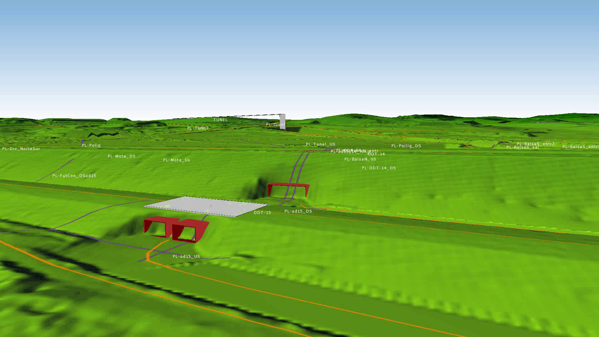
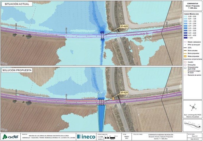
- Conventional railway lines: For Adif: Flooding study: Cartagena Arterial Railway Network. Underground access to Cartagena Station (2022). Improvement of existing drainage works on the Bobadilla - Algeciras line. Section: Bobadilla-Ronda. (2021). The preliminary project to improve the hydraulic capacity of the river Corbones under the conventional railway and AVE Madrid - Seville lines, in the area of Guadajoz, Seville (2021).
For the Ministry of Transport, flooding studies for the environmental file of the informative study of the Tren de la Costa, Valencia-Alicante Phase II railway line, Cullera-Gandía section (currently being drafted), and a hydrological and hydraulic study and solutions for improving drainage between Km points 366+800 to 368+800. Line from Alcázar de San Juan to Seville (2010).
- High speed: For Adif: Floodability study of the Rosa stream, on the Madrid - la Sagra - Toledo high speed line (2023). Study of measures to improve drainage against flooding in the municipality of Benifaió, Valencia (2021) or studies of rain damage mitigation measures on the Monforte del Cid- Murcia high speed line in the area of the Reguerón, in Alquerías, and in the Font de la Figuera tunnel, Valencia (both in 2020) Also, studies of drainage improvement measures against flooding in the municipality of Monforte del Cid (2021), and in the vicinity of the Font de la Figuera tunnel in extraordinary rainfall events (in drafting)
For the Ministry of Transport, hydrological-hydraulic study of the 323.5 autotransformer station on the Murcia-Lorca section. Murcia-Almería high-speed train line (2022).
- Carreteras: Flooding studies of the Alguema and Regatim watercourses and the Pont de Molins by-pass, both in the project for the layout and construction of the increase in capacity of the N-II road, Girona (currently being drafted).
- Environmental actions: For the Ministry for Ecological Transition (MITECO): Floodability study of the construction project for flood prevention and adaptation of the Adra riverbed, Almeria (2021), technical assistance to the works for the hydrological-forestal restoration and reduction of flood risk in the wadis of the Cartagena mining area (2021).Technical assistance to the works for the hydrological-forestry restoration and flood risk reduction in the wadis of the Cartagena mining area (2023), as part of the Mar Menor recovery actions.
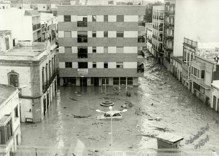
The centre of Adra after the great flood of 1973.
Solutions proposed in the study to improve the drainage works on the Bobadilla-Ronda section of the conventional Bobadilla - Algeciras line. Source: ADIF
04
Climate resilience studies
In addition to flood studies, Ineco also conducts resilience analyses of infrastructure in the face of the potential impacts of climate change, in which, although multiple variables are considered, rainfall also plays a special role.
"The fate of humans and water are intrinsically linked". Audrey Azoulay, Director-General of UNESCO. (The Value of Water, United Nations World Water Development Report 2021).
Thus, for instance, the resilience study of the Madrid-Seville high-speed line carried out by Ineco in 2023 revealed that, of all the climatic incidents recorded on the line during the last decade, 387 in total, 60% were related to rainfall, far ahead of other variables such as wind (17%) or storms (13%).
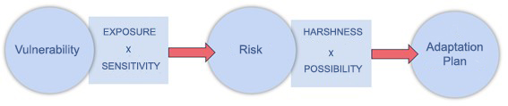
Processes of infrastructure resilience studies to climate change impacts. Source: Own elaboration.
This type of study analyses the vulnerability, risks and adaptation plan of railways, roads, airports and ports to the effects of climate change. The first step is to identify vulnerable areas, taking into account which climate hazards are most affected based on the characteristics of the infrastructure (sensitivity) and its location (exposure). The level of risk (from "negligible" to "catastrophic") is then assessed according to its likelihood and severity. Finally, adaptation measures are proposed to reduce the level of risk and to create more resilient infrastructure, such as the construction of storm tanks, flood control basins, increasing the size of drainage works, etc.
In Spain, this type of study has already been carried out on more than 50% of the railway infrastructure, and will continue until the entire network is covered, as well as on the State Road Network and at numerous airports. Externally, the company is advising Rail Baltica (the future high-speed line connecting Estonia, Latvia and Lithuania) in the field of resilience for Climate Proofing, in compliance with EU requirements.


