
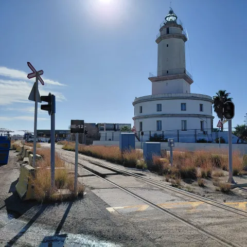
Within the Port of Barcelona, the railway network coexists with pedestrian routes and intense logistics activity. Analysing these intersections in a consistent manner is essential to understanding their characteristics, comparing different situations and supporting decision-making. To this end, Ineco has studied 34 locations where railway infrastructure and pedestrian routes converge, developing a methodology that enables each site to be characterised using objective, measurable and traceable criteria. The result is a tool that can be adapted to other ports and infrastructures with similar configurations.
Rail operations share space with vehicles, workers and other pedestrian movements within an industrial environment that is constantly in motion. Each crossing presents different conditions and therefore requires an assessment tailored to its configuration, surroundings and operational use.
To bring structure to this complex reality, the Port of Barcelona Authority (APB) commissioned Ineco to study pedestrian crossings across its railway network. The objective was to establish a diagnosis and a common methodology capable of characterising these intersections, assessing their level of risk, identifying needs and prioritising actions using consistent technical criteria. The work combined cartographic analysis, site visits, photographs, video recordings, measurements and a review of documentation provided by the APB.
For each of the 34 identified crossings, a technical datasheet was produced using a common structure. These records include location, function, rail and pedestrian flows, physical characteristics, existing protection measures, visibility conditions and crossing risk level. This systematic approach makes it possible to compare highly diverse situations against the same set of criteria and to understand each crossing within the wider route network and operational context that surrounds it. The study is complemented by an individual functional assessment that considers the specific characteristics of each location and identifies potential improvement measures.
One of the project’s main challenges lay in its unique regulatory context. Under Royal Decree 929/2020, crossings between roads or paths and railway lines located within industrial or port areas, or on their access routes, are not classified as level crossings. In such cases, protection systems, risk mitigation measures and operating conditions must be defined within the infrastructure manager’s Safety Management System. This regulatory particularity required the development of a dedicated assessment approach tailored to the operating conditions and pedestrian movements specific to the port environment.
Drawing on regulatory analysis, fieldwork and comparisons with established railway procedures, Ineco developed a bespoke methodology and calculation tool to estimate the risk of train-pedestrian collisions at pedestrian crossings. The methodology brings together four dimensions within a single assessment: exposure, operational conditions, environmental characteristics and existing protection measures.
Factors considered include estimated pedestrian flows, railway traffic intensity data recorded by the APB, train operating speeds, accident history, visibility conditions and infrastructure condition. The assessment also evaluates the effect of protection measures such as vertical and horizontal signage, pedestrian traffic lights, audible warning devices and pedestrian route channelisation systems.
The calculation method developed demonstrates significant potential for replication and adaptation. It can be applied not only within the port environment covered by the study, but also in any other port or infrastructure where railway operations interact with pedestrians under similar operating conditions. Its modular design and its use of operational and safety variables that can be easily parameterised allow it to be adjusted to different network configurations, rail traffic patterns and operating environments, contributing to enhanced safety and risk management across a wide range of railway settings.
The outcome is a classification system based on four levels: very low, low, medium and high. This framework translates technical information into practical management guidance. Depending on the category assigned, it may be sufficient to continue monitoring the crossing, necessary to investigate potential improvements or, in the most critical cases, appropriate to consider more substantial interventions, including the possible removal of the crossing.
The study also includes GIS-based georeferenced documentation, cartographic representation, individual crossing records and a photographic archive. In addition, it incorporates calculations of distances to various points of interest, helping to interpret how each crossing is used within the wider port environment. This information also facilitates future updates to the inventory and ensures the traceability of decisions taken over time.
The conclusions are advisory in nature and provide the APB with a robust technical basis for evaluating and prioritising potential actions. These may include the implementation or enhancement of information and warning systems, improvements to pedestrian infrastructure, modifications to specific operating conditions and the introduction of monitoring and supervision activities.
The value of the project lies not only in identifying where intervention may be most urgently needed. Its true significance is in transforming a complex environment into a system that is measurable, comparable and traceable. When every crossing is assessed according to the same criteria, it becomes easier to establish priorities and act where improvements can make a meaningful difference.